

ESA satellite images show climate catastrophes in 2022
In Germany, the most extreme heat is over, but not the drought. Elsewhere, however, people are still suffering. Satellite images indicate the extent.
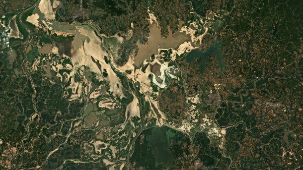
China's largest freshwater lake is largely dry
(Bild: Copernicus Sentinel data 2022)
(Hier finden Sie die deutsche Version des Beitrags)
Heat waves, droughts, floods - the extreme natural disasters of this year can even be seen from space. On the freely available data from Europe's Earth observation satellites, the consequences of the heat and drought in China in particular are becoming increasingly clear. But the consequences of devastating forest fires in Europe and the catastrophic floods in Pakistan can also be impressively traced from space. The satellite images thus also show the consequences of the climate catastrophe, which has very different effects worldwide.
Satellite images of climate disasters 2022 (32 Bilder)

Southern China is currently suffering from the worst heat wave in history. As a result of the extreme temperatures and the drought, dozens of rivers have already dried up, with serious consequences for the electricity supply. This is because electricity depends heavily on hydropower. Meanwhile, in Pakistan, large parts of the country are flooded and more than 1000 people have already died. According to the country's disaster agency, almost one million buildings have been damaged.
Videos by heise
For years, the European Space Agency (ESA) has been a world leader in not only collecting Earth observation data, but also making it available - not only for science. With the Copernicus programme, it is also far ahead of the US space agency NASA. These data are particularly useful for environmental protection, for monitoring the climate, for agriculture and, repeatedly, for relief after natural disasters. They are available to the general public free of charge, including the images in visible light taken repeatedly at intervals of a few days with a resolution of 10 metres.
Most recently, however, there has been a setback for ESA: The Earth observation satellite Sentinel-1B from the Copernicus fleet, which has not been functioning since the turn of the year, had to be abandoned. Its successor, Sentinel-1C, is to be launched in the second quarter of 2023. However, images in visible light will be taken by the Sentinel-2 satellites.


(mho)
