

Fraunhofer creates 3D visualizations of danger zones with lidar laser
The Fraunhofer FKIE uses a lidar laser to quickly create virtual 3D environments in hazardous situations.
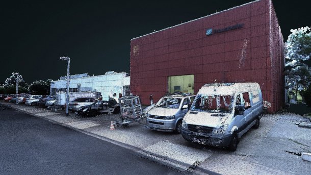
The image shows a virtual 3D environment created with the Fraunhofer FKIE lidar laser.
(Image: Fraunhofer FKIE)
In the “3D-InAus” project, the Fraunhofer Institute for Communication, Information Processing and Ergonomics (FKIE) has used a Lidar laser on a mobile robot to create an exact digital 3D copy of environments using laser pulses. The system is designed to generate a virtual 360-degree image in dangerous situations, for example. This enables emergency services to create a better picture of the situation more quickly.
In dangerous situations, it is advantageous for emergency services to have information about the surroundings in advance so that they can better plan their response. Fraunhofer uses a Lidar laser mounted on a mobile robot. The robot uses pulsed light to scan its surroundings and measure exact distances. The data is then used to create a 3D image of the surroundings of buildings, interiors and open spaces, including objects. Users can then move freely in the 3D environment virtually and use it to plan their operations.
“Compared to robotic systems that explore a danger zone with cameras, our project goes a big step further. The laser pulses provide measured values for the exact 3D mapping of a terrain or building. Distances and dimensions are not estimated, but determined to within a few centimeters,” says Timo Röhling, Technical Project Manager in the Cognitive Mobile Systems department.
Videos by heise
Combined laser and camera data

(Image: Fraunhofer FKIE)
The system combines a Lidar laser with a camera system with up to six cameras. The Lidar laser is mounted on a turntable. A rotating mirror in the Lidar module ensures that a section of 16 vertical slices can be scanned ten times per second. The vertical sections form a complete all-round view horizontally. The system uses a total of 1.3 million laser pulses per second for scanning. The reflections of the laser from the surroundings are used to determine their transit time and the distance.
The remote-controlled or semi-autonomous robot moves continuously through the terrain and collects environmental data in the process. To deliver correct results indoors without GPS reception, the engineers at the FKIE have created a kind of virtual GPS. From the known dimensions of the building and its position, exact position data can be determined for autonomous navigation in the building.
The distance data determined by the robot is pre-processed on the mobile robot and later combined with images from the cameras in stationary post-processing. The camera images are used to colorize the surroundings and objects with suitable colors.
According to the FKIE, the mapping process of a 400 × 400 m area takes around three hours. This can be accelerated in cases of high urgency, so that an initial model of the environment is available after just one hour. To achieve results more quickly, several robots can be used and their data combined.
The FKIE researchers emphasize the flexibility of the system, which can basically be used on different robot systems and drones. The project was commissioned by the German Armed Forces to create complex situational images in unknown terrain formations, for example in dangerous situations. The robot system can also detect toxic substances or radioactive sources using integrated sensors and locate them in the virtual environment.


(olb)
