

NASA's Aviris-5 Detects Lithium and Other Minerals from Aircraft
With a new imaging spectrometer from NASA, mineral deposits in the ground can be identified from an aircraft. The sensor is housed in an airplane.
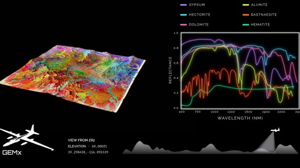
The photo schematically shows how a geological map is created from the captured reflectance data.
(Image: JPLraw/Screenshot)
Scientists at the Jet Propulsion Laboratory (JPL) of the US space agency NASA have developed Aviris-5 (Airborne Visible/Infrared Imaging Spectrometer 5), a high-precision imaging spectrometer that can scan rocks on the Earth's surface from an aircraft for potential deposits of lithium and other important minerals. The method uses unique reflection patterns to detect minerals and map potential deposits.
Aviris-5 is about the size of a conventional microwave and is housed in the nose of the NASA research aircraft ER-2, which is used for geological mapping of the Earth's surface together with the U.S. Geological Survey (USGS), the geological agency of the USA.
The sensor detects the spectral, unique light patterns of minerals and other compounds in reflected sunlight. This works because the molecules of lithium, rare earths, and also floral pigments have unique chemical structures that absorb and reflect different wavelengths of light accordingly.
Empfohlener redaktioneller Inhalt
Mit Ihrer Zustimmung wird hier ein externes YouTube-Video (Google Ireland Limited) geladen.
Ich bin damit einverstanden, dass mir externe Inhalte angezeigt werden. Damit können personenbezogene Daten an Drittplattformen (Google Ireland Limited) übermittelt werden. Mehr dazu in unserer Datenschutzerklärung.
The sensor essentially consists of mirrors, detector arrays, and electron beam gratings. These are used to capture the light reflected from the surface and then, like a prism, break it down into individual colors.
Reflectance data for identifying mineral deposits
Aviris-5 scans the Earth's surface. From the determined reflectance data, a map is created that breaks down the different wavelengths in nanometers. From these, scientists can identify which minerals are located where on the Earth's surface. For example, hectorite, a lithium-containing clay, can indicate that there is a lithium deposit beneath the Earth's surface. This information can be used to initiate prospecting that can identify profitable mining areas for important raw materials.
However, JPL's technology is not entirely new. As early as the late 1970s, JPL developed various imaging spectrometers adapted to specific missions to send to rocky planets like Mars, Mercury, and Pluto to determine their specific composition. For example, one of these imaging spectrometers was the first to discover water on the lunar surface in 2009.
Aviris-5 is already the fifth version of the Aviris sensor, which was first used in 1986. The older imaging spectrometers have since been used to analyze volcanic eruptions, diseased crops, debris at Ground Zero in New York, and wildfires in Alabama. JPL has continuously developed the sensor over the years. The latest version has a significantly higher resolution than its predecessors and can resolve individual areas from less than 30 cm to 10 m.
Videos by heise
In 2025, Aviris-5 had already been in operation for over 200 hours in the USA as part of the Geological Earth Mapping Experiments (GEMx) over the US states of Nevada and California and other western US states to geologically map the Earth's surface.


(olb)