

Without GPS: Maxar uses visual navigation system for military drones
Maxar Intelligence uses image data from a drone's on-board camera and compares it with 3D terrain data to determine its position. GPS is not required.
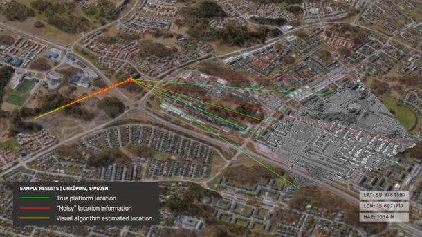
The sub-component of the GPS-less navigation system, Raptor Guide, uses a drone video to determine its position.
(Image: Maxar Intelligence)
Maxar Intelligence, a subsidiary of the US satellite company Maxar Technologies, has developed Raptor, a visual-based navigation system that works completely without GPS. The company announced this on Tuesday. The system is primarily intended for use in military drones, for example when the drones are to operate in areas where the GPS system is disrupted.
Raptor uses detailed 3D models of the earth's surface. Maxar-Intelligence converts images from its own earth observation satellites into 3D data. A drone equipped with Raptor compares these 3D terrain models with the current images provided by the drone's camera. This enables the drone to determine its exact position and orient itself accordingly. This works in real time, writes Maxar Intelligence, and should also work in the dark. However, the company leaves open how exactly this is supposed to work.
Behind this is a system that is essentially based on three components. Raptor Sync compares the drone's video recordings with the terrain data. Raptor Guide uses this to determine the position of the drone. A third piece of software, Raptor Ace, runs on computers at a ground station that is in contact with the drone. This makes it possible to extract precise ground coordinates from the video recordings of the drone camera.
Videos by heise
Maxar Intelligence promises that the 3D terrain data is updated regularly. It is also possible, at the customer's request, to recapture certain regions with the company's own earth observation satellites and provide the latest data. The satellite images are converted into 3D data using technology from 3D geospatial specialist Vricon. Maxar acquired the company back in 2020.
Military application
Maxar Intelligence sees potential applications in the commercial sector, but primarily for military use. As the system does not require GPS signals, weapons systems that rely on precise positioning can still function even if the GPS signal is disrupted. The data for this is provided by drones equipped with Raptor. The system can be used on any camera drone, so it is not limited to a specific type. This makes it possible for drones and autonomous systems to exchange their navigation data in order to act in a networked manner in military operations. This is also possible with ground systems and other target systems, according to Maxar Intelligence.
The system was tested by Maxar Intelligence with several customers for several months in advance. Maxar Intelligence has adapted its business model with the Raptor navigation system. Previously, the company only supplied satellite images and data to customers and provided special software solutions. Now Maxar Intelligence has also become a system provider.


(olb)